Giant’s Grave north of Pewsey
It’s amazing what you can find just by browsing through the Ordnance Survey Leisure Map at 1:25K scale. I do this online when planning a narrowboat trip so that I know in advance of a stately home or neolithic burial site that might be convenient to the canal. Of course when considering a trip on the Kennet & Avon Canal in Wilthsire (and Berkshire) one is spoiled for choices.

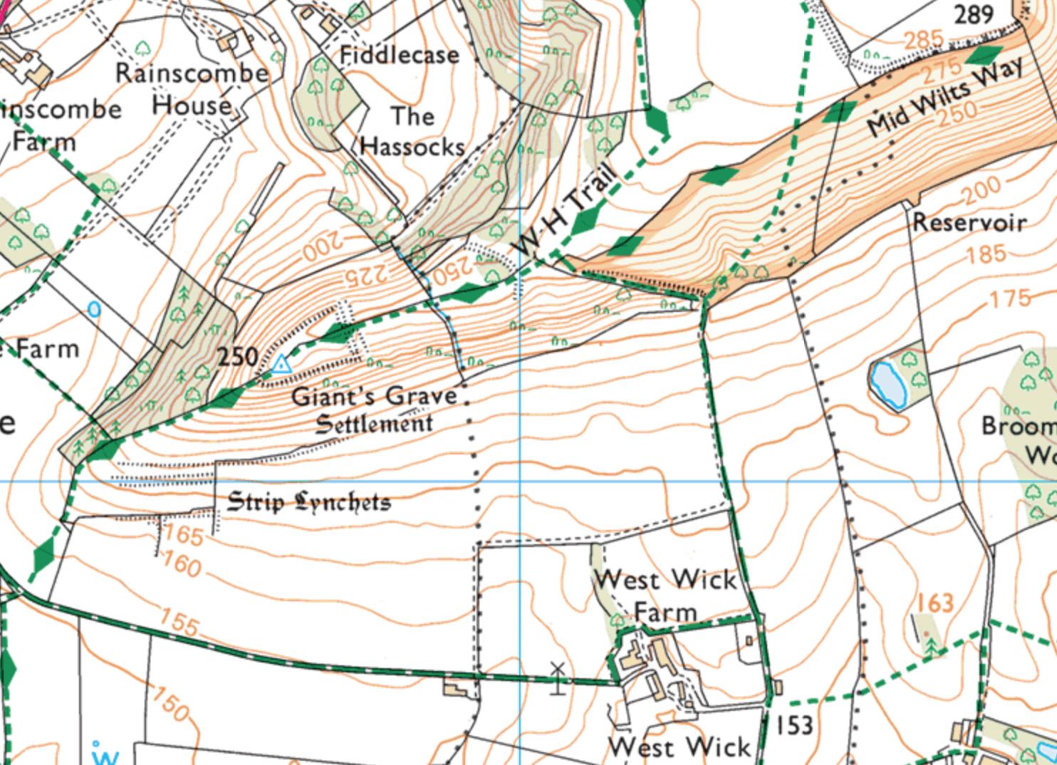
The Giant’s Grave just north of Pewsey is a perfect example of what I’m talking about. I scan a few miles to either side of a canal to see what’s within a reasonable walking distance and I found Giant’s Grave marked in the characteristic Gill Sans font with an underline in Black Letter that says “Settlement.” Looking more closely on the map I realized that White Horse Trail and Mid Wilts Way pass through what is obviously a promontory judging from the contour lines.
A quick Google search confirmed that this is Martinsell Hill, the third highest point in Wiltshire at 948 ft/289 m, and that there is indeed an Iron Age hillfort at (or near) this spot. There is a commanding view of the surrounding area from the hillfort and looking south in the picture above you can almost see the K&A in the Street View, or at least you can see the White House Trail that leads to the canal.
It’s about a 1.6 mi/2.6 km walk on the White Horse Trail, which crosses the canal at Bridge 113, to Giant’s Grave. There’s also a much longer 6.5 mi/ 10.5 km circular walk from Pewsey Wharf for the more ambitious. Unfortunately I’m not sure why it’s called Giant’s Grave. I don’t think the site is a barrow, but confusingly there is a Giant’s Grave Long Barrow southeast of Pewsey, a short distance from the White House, and a Giant’s Grave Long Barrow south of Salisbury. My guess is that at some point someone thought the hillfort to be a gigantic barrow. I’m also unsure if the site marked Giant’s Grave was part of the main hillfort (about 0.74 mi/1.2 km north northeast) or a separate settlement.
Martinsell Hill was definitely a settlement, however, as evidenced by the strip lynchets, or terraced farming plots, on the south side of the promontory. Of course everywhere you look on the OS map you’ll find earthworks, tumuli (burial grounds), dykes and mounds. The Giant’s Grave is pretty distinctive with a ditch cutting through the hill, which you can see marked on the OS map above.
As a bonus to your hike to Giant’s Grave, you might want to include a visit to nearby Oare House and it’s stunning gardens—that is if your visit coincides with the garden’s two open days. It’s a private home but as part of the National Open Garden Scheme it, and many other stately homes that aren’t already associated with the National Trust or English Heritage, make their gardens accessible to the public. If you’re considering a visit to the UK and have an interest in horticulture, it’s worth your while to see if there’s a garden open day somewhere nearby.
And before saying goodbye to Giant’s Grave and Martinsell Hill, I thought I’d mention that Wiltshire is the crop circle capital of the UK, and that Martinsell Hill is no stranger to this phenomenon.

