
Boating, Biking and Hiking the Kennet & Avon Canal
I’ve just started work on my next guide, which will explore the Kennet & Avon Canal. It’s a return to the K&A for me, my husband and my friends, because it was the first canal we traveled. That 2011 trip was only a mid-week break, meaning four nights and five days and so we only managed to go from Bath to Devizes … and we skipped the daunting Caen Hill flight of locks.
This time we’ll be traveling east from Devizes, or rather Foxhangers boat hire, so our first task will be the lock flight. We’re planning to at least make it to Hungerford and perhaps Kintbury, but I doubt we’ll get as far as Newbury, because we want to explore as many of the archaeological sites as possible.
In order to make a comprehensive guide, however, I’ll be leaving before the others so that I might ride a bike the length of the canal from Bristol to Reading. To save money, I’ll be camping and staying at hostels whenever possible, so I believe I’ll know the canal about as intimately as possible.
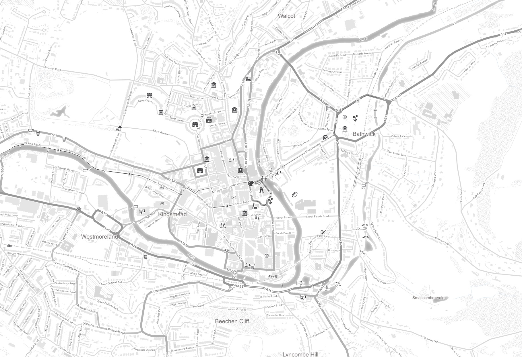
I’ve already begun work on the guide and the first step is creating the maps used in the book. I was very happy to find out that the Ordnance Survey has a free media license, allowing me to use their maps in my books (unlike Google, which forbids the use of their maps in travel books), and that they recommend a geographic information system software and some tutorials on how to use it. Previous attempts at using GIS on my computer failed miserably, but QGIS seems to be working great. More on that later.
It’s quite an interesting and convoluted process creating these maps. I’ve downloaded the OS Local Maps, which shows every minor street and building, forested areas, rivers, highways, etc. These maps are best viewed at 1:10,000 scale, which means a full-page map in a 5.5×8.5 inch book can display almost three and half miles in width. (I actually reduce the 1:10,000 scale map to 40%.) Unfortunately the K&A is 87 miles long, which means this will be a fairly big book.
Unfortunately the OS Local Map doesn’t include canal information such as locks, bridges, aqueducts and winding holes, so for that I have to download data from the Canal & River Trust. What is not included, however, is data on services (water points, toilets, pump out, etc.) and moorings. For that I have to scour the CRT maps of the canal and river network. It’s possible to zoom into the map of the Kennet & Avon, for instance, and identify the location of each service and mooring,
I then plot that information into a Google Map, which allows me to switch into satellite view, making it easier to precisely place a marker. Also in Google Maps, I can identify museums, stately homes, pubs, restaurants, cafés, tourist information centers, hospitals, post offices, etc. close to the canal.
Of course I pay great attention to the towpath for those people cycling or walking the canal. I need to know when it switches from one bank to another, where it cannot follow the canal (going through a tunnel for instance) and when it changes from paved to gravel to dirt. For that I depend on the CRT accessibility map, with that data cross-checked in Google Maps satellite view. Sadly the accessibility map can only be viewed in a small window and is very tedious to navigate.

The downloaded OS Local Map also doesn’t include information about hiking trails and sites of archeological interest, which you can see in paper OS Landranger 1:50,000 scale or 1:25,000 scale Explorer maps. To find and plot that information, I create route maps in the online OS Leisure Map (a free service of the Ordnance Survey for the standard map but a subscription to access the Leisure Map) of the walking trails such as the Wessex Ridgeway.
The OS Leisure Map, however, can be a nightmare for tracing a trail because the map includes every foot and bridle path, official or otherwise. I often rely on Open Street Map to confirm these paths because I’m able to query nodes and lines to see what it belongs to, something that’s impossible to do on the OS maps, which are sadly lacking in interactive features.

Actually many of the long-distance walking trails of the UK can be downloaded from the many websites devoted to walking in the UK, but what’s not available is downloadable data of the national cycling network. I was able to download the path of the Bristol to Bath Railway Path, but not the entirety of National Cycle Route 4 that closely follows the path of the K&A Canal. To do that I again trace the route of the cycle route in the online OS map, which displays (for free) the National Cycle Network. Again I often cross-check the route of the cycle routes in Open Street Map.

I also use a combination of maps to find the location of the many pillboxes scattered along the length of the Kennet & Avon. The OS Local Map doesn’t label the pillboxes as such, but if you zoom in you can often find small rectangular or hexagonal features that represent these last-ditch efforts to foil a German invasion of the island in the early days of World War II. Open Street Map often represents pillboxes with a characteristic icon and querying reveals the object as a “bunker.”
Often, however, both the online OS map and Open Street Map fail to show these wartime fortifications. I would miss many of these pillboxes just by referring to maps, so I also Google phrases such as “Kintbury pillbox” and find a variety of online sources. Unfortunately the accompanying maps at these sites aren’t always useful so the other resource I employ is Google Maps satellite and Street View. One pillbox near Wootton Rivers isn’t shown on the OS Leisure Map or at OSM, but it is obvious on satellite images (unlabeled) at either Google Maps or the Ordnance Survey. However there’s also a Google Street View that shows the pillbox is directly observable from the towpath of the canal (the pillbox is on private land). I have discovered pillboxes just by virtually walking the Street Views along the canal.
Once all this data is collected or created, it’s imported into into QGIS, a free, open-source mapping program (or geographic information system). QGIS allows me to style the information, which is otherwise imported as just dots and lines, with no distinction between major and minor roads, big cities or hamlets. I’ll delve into QGIS in a subsequent article.

